Data Collection and Mapping of Sewered and Unsewered Areas
Purpose of the Project
One of the projects from NEFCO’s State Fiscal Year 2022 water quality contract with the Ohio EPA was to assist the agency in collecting data and information on unsewered areas in the NEFCO region. Ohio EPA will use this information as it determines how to allocate funding to provide sewer connections and home sewage treatment system (HSTS) upgrades for identified areas in the Region. This collaborative project was completed in each of the six Ohio Areawide Planning Agencies regions. Biweekly meetings were held with the Areawides’ water quality staff and staff from the Ohio EPA to refine what information was needed, and if that data existed or needed to be collected. The product deliverable was to map the data electronically via NEFCO’s geographic information system (GIS) and to provide it to Ohio EPA.
Ohio EPA’s goal for this project was to gather information for identified ‘problem areas’ which lack access to sanitary sewers. The agency will use this and other information in its decision-making process to distribute funds for sewer extensions/connections to areas that are at or below the federal poverty level (disadvantaged areas). Funds may also be available for extending sewer to mobile home parks (MHPs) with ‘package’ (wastewater treatment) plants. Ohio EPA wants to be able to quickly assess where the MHPs are in relation to existing sanitary sewer and the distribution of problem areas in identified disadvantaged areas. This information will be used by the Ohio EPA in the determination of funding (federal or state) for future sanitary sewer projects.
Who’s Involved
The collaborating partners involved with this project were NEFCO and the five other Ohio Areawide Planning Agencies, and the Ohio EPA. The local agencies that are assisted NEFCO by providing data on sewer lines and priority areas for needed sewer connections are the wastewater management agencies (sewer authorities), county and city health departments, and other regional stakeholders.
Funders
 To pay for this project, NEFCO used funds from one of the two annual water quality management planning contracts it has with the Ohio EPA. This Ohio EPA contract utilizes federal funds that Ohio EPA receives from U.S. EPA for the development of studies and plans to reduce water pollution, especially from nutrients.
NEFCO’s Role
NEFCO’s role was to coordinate data collection and analyses that have been requested by the Ohio EPA for the Region, and to interact in the collection of this data with NEFCO’s local agencies and governments. NEFCO provided Ohio EPA with the following geographic information system (GIS) data and mapping:
- Areas currently served with sanitary sewers within Portage, Stark, Summit, and Wayne Counties
- Any priority areas for sewer connections identified by regional stakeholders, including the county and city health departments, and sewer authorities
NEFCO’s role was also to support Ohio EPA’s efforts to collect the following data for our Region:
 Population
- Disadvantaged communities
- Housing density
- Median home value
- Water quality impairments
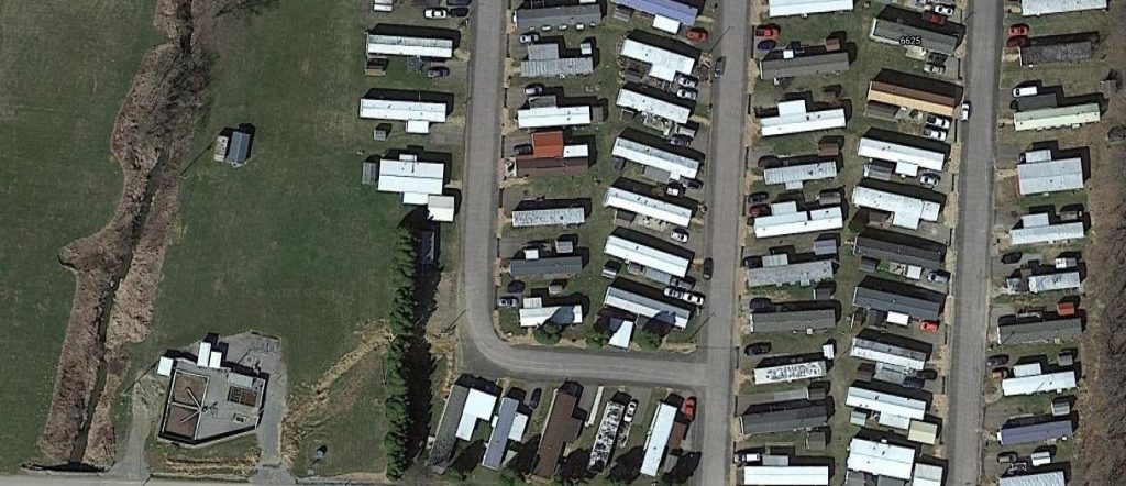
- Mobile home parks and package plants with NPDES compliance issues
Progress to Date
This collaborative project began on July 1, 2021. For the next several months, NEFCO staff collected the data needed for the project from the local health districts, the wastewater management agencies (MAs), and Ohio EPA, and participated in project meetings with the other Areawide Planning Agencies and Ohio EPA Central Office staff. The affected MAs with wastewater jurisdiction in the priority unsewered areas (PUAs) identified by the health districts for this mapping project, agreed that the health districts’ priority areas are the MAs’ priorities, provided the MAs have a voice in scheduling any sewer projects resulting from funding being made available from this mapping project. On May 26, 2022, NEFCO staff attended a final collaborative mapping project meeting with the other Areawides and Ohio EPA to discuss the status of each Areawide’s deliverables, final deliverables, the timeline for completing the project, and delivering the product to Ohio EPA’s Central Office. On June 22, 2022, NEFCO’s GIS staff provided the shapefiles of the entire NEFCO region’s PUAs to Ohio EPA’s GIS staff, who confirmed receipt on June 29, 2022, thus finalizing this project.
What NEFCO’s map of PUAs Is and Is Not
 NEFCO’s “working map” of priority unsewered areas (PUAs) is a planning tool for Ohio EPA to use as it determines how to allocate funding to provide sewer connections and home sewage treatment system (HSTS) upgrades for identified PUAs in Portage, Stark, Summit, and Wayne Counties. The map of PUAs is an efficient way for Ohio EPA and others to see the priority areas that lack access to sanitary sewers, as identified by the local health districts, which regulate HSTSs, with concurrence from the wastewater management agencies (MAs), which own, operate, and maintain the sanitary sewers that are tributary to their publicly owned wastewater treatment plants. The map is also an efficient way for Ohio EPA and others to see the PUAs that are below, equal to, or two times the federal poverty level (disadvantaged areas) and mobile home parks without access to sanitary sewers.
Since the map of PUAs is overlayed on NEFCO’s interactive online 208 Plan map, which has a digital measuring tool, it is also an efficient way for Ohio EPA and the MAs to measure the distance to the nearest areas currently served with sanitary sewer when planning sanitary sewer extensions to a PUA and for the MAs to convey to Ohio EPA their wastewater infrastructure needs when applying for funding. The map is also expected to be used by the Ohio EPA in the determination of funding (federal or state) for future sanitary sewer projects.
NEFCO’s map of PUAs is not an indicator that a mandatory connection to sewer is imminent for a neighborhood in a PUA.
Ohio EPA is still evaluating the information provided by NEFCO for this project, which could result in changes to the map of PUAs by Ohio EPA (or others).